
Midtown Oakville: A Strategic Urban Growth Centre
阅读量:146
Introduction
Midtown Oakville is the Town’s primary strategic growth area, envisioned to accommodate a significant portion of the Town and Region’s required intensification until 2051 and beyond. Covering approximately 103 hectares, it is bounded by the QEW/Highway 403 to the north, Chartwell Road to the east, Cornwall Road to the south, and the Sixteen Mile Creek valley to the west.
Strategic Location and Transit Connectivity
This urban growth center and protected major transit station area is strategically positioned along the Lakeshore West GO provincial priority transit corridor. It is centered around the Oakville GO/VIA Station, serving as the Town’s primary hub for current and future transit services. Currently, the area is served by regional and inter-regional rail and local and inter-regional bus systems, including Via Rail, GO Transit, and Oakville Transit. Future plans include the integration of bus rapid transit (BRT) systems, connecting Midtown Oakville with the broader Greater Toronto and Hamilton Area (GTHA) transportation network.
Growth Plan and Development Requirements
Designated as one of the 25 urban growth centers in the Province’s Growth Plan for the Greater Golden Horseshoe since 2006, Midtown Oakville holds a critical role in accommodating future population and employment growth. The Growth Plan mandates that Midtown Oakville achieve a minimum density target of 200 residents and jobs combined by 2031. The Town, in collaboration with regional and provincial partners, is committed to implementing a comprehensive plan to provide the necessary infrastructure, programs, services, and incentives for development.
Goals: Create a Vibrant, People-Oriented, and Transit-Supportive Community
- Establish a mix of high-density and compact residential, commercial, and employment uses, along with educational facilities and public service facilities. Enhance public spaces with open areas and public art to attract diverse users throughout the day and year-round.
- Foster a continuous, well-connected, and robust public realm, emphasizing human interactions and active uses at the street level.
- Uphold high urban design and architectural standards for both development projects and the public realm.
- Facilitate public investments in transit, infrastructure, and public service facilities, ensuring that development density aligns with the required infrastructure through the town’s planning approval process.
- Coordinate the provision of future roads and transportation infrastructure as development progresses, ensuring timely support for new residents and employees.
- Promote the use of district energy and sustainable building practices, in alignment with the Oakville Community Energy Strategy.
- Direct major office and appropriate large-scale institutional developments to Midtown Oakville.
Objectives
As Midtown Oakville evolves, the Town will utilize the following objectives to guide decision-making in reviewing planning applications and development proposals:
-
To create a vibrant, people-oriented, transit-supportive, and complete community by
a) providing a mix of high-density and compact residential, commercial, and employment uses, educational facilities, and public service facilities, complemented by publicly accessible open spaces and public art, to attract different users throughout the day and year-round;
b) creating a continuous, well-connected, and robust public realm focused on human interactions and active uses at grade;
c) ensuring a high standard of urban design and architectural quality for development and the public realm;
d) facilitating public investment in transit, infrastructure, and public service facilities to support growth by matching density with required infrastructure through the town’s planning approval process;
e) Requiring that the provision of future roads and other transportation infrastructure shall be coordinated as development progresses to ensure that transportation infrastructure is provided for new residents and employees in a timely manner;
f) promoting the use of district energy and sustainable building practices, in alignment with the Oakville Community Energy Strategy; and,
g) directing major office and appropriate large-scale institutional development to Midtown Oakville.
-
To create transit-supportive communities by:
a) ensuring the entire area is developed as a place that prioritizes people,
active transportation and transit;
b) improving connections to and through Midtown Oakville for active
transportation and public transit;
c) reducing parking standards over time to promote transit ridership and
facilitate mixed-use development;
d) ensuring a compact urban form with high density and high intensity
land uses while providing a high-quality, active transportation-focused
public realm; and,
e) aligning the planning and implementation of transit-supportive
infrastructure, transit services and operations with new and existing
development.
-
To enable the evolution of Midtown Oakville as an urban growth center and the Town’s primary growth area by:
a) planning for a minimum gross density of 200 residents and jobs
combined per hectare – a minimum of 20,600 residents and jobs – by
in accordance with the Growth Plan;
b) ensuring that development occurs in a comprehensive and progressive
manner by monitoring key development indicators at regular intervals;
and,
c) ensuring future population growth, beyond 2051, is accommodated
through sufficient infrastructure planning.
-
To attract new investment, and retain and grow existing businesses to enhance the economic development of Midtown Oakville by:
a) promoting the economic function of the Midtown Oakville area by
providing a mix of office and other uses to support employment;
b) promoting partnerships with existing post-secondary institutions,
economic development and innovation organizations, and local
businesses to support new and emerging companies; and,
c) introducing an incentive strategy, policies, and zoning regulations,
informed by an economic development strategy, that will promote and
support business and talent attraction goals.
Midtown Community Framework
In addition to the policies in Parts C and D of this Plan, the following
policies apply specifically to Midtown Oakville. They set out the framework
of components required to build the community envisioned by this Plan.
Midtown Oakville shall be designed as a regional destination and urban
community with a compact form, complete with a mix of building forms and
types, which will include tall and midrise buildings, framing a public realm
that prioritizes active transportation and transit use. New developments
and public realm improvements shall support this direction.
-
Population and Employment
a) In accordance with the Growth Plan, Midtown Oakville has been
planned to achieve a minimum gross density of 200 residents and jobs
combined per hectare by 2031. Based on its gross area of 103
hectares, this translates to a minimum of 20,600 residents and jobs.
b) An overall mix of at least 7,875 residential units and a gross floor area
ranging from 165,000 to 510,000 square metres of retail, service
commercial and employment space should be accommodated to
provide for a minimum of approximately 13,390 residents and 7,210
jobs.
-
Public Realm
A major feature of Midtown Oakville will be its public realm – comprised of
a “campus of parks”, public streets, as well as privately-owned publicly
accessible open spaces (POPS) – designed to create a desirable place for
residents, workers, and visitors alike.
As a compact urban community and destination, the planning, design, and
implementation of the public realm in Midtown Oakville will be influenced
by the Urban Park Hierarchy for strategic growth areas, outlined in the
Town’s Parks Plan. Urban park spaces are diverse, flexible and
connected, contain a mixture of green and hardscape design components,
and are inherently connected to the public realm.
The urban parkland system includes primarily public spaces but can also
include semi-public spaces and private components that form an
interconnected network, animated by people who walk from place to place.

Key components of the urban parkland system that will influence the
Midtown Oakville public realm include the following:
- Public commons, which are large social and recreational focal
points that meet the needs of the local community, support a
balance of active and passive uses, and shall be coordinated with
urban school sites, where possible. Public commons accommodate
special features that contribute to placemaking, including locations
for public art.
- Promenades are substantial linear spaces, located between
adjacent building facades and the adjacent road right-of-way, used
to enhance the pedestrian experience together with highly activated
at-grade retail spaces. Promenades may include public art, small
outdoor game areas, seating, places to eat and relax, as well as
street-related activities such as vendors and exhibit spaces.
- Urban squares support community-oriented social opportunities, as
well as town-wide entertainment and cultural events depending on
their size and location. Urban squares may include many of the
same uses and amenities as promenades.
a) The public realm shall incorporate networks of accessible,
interconnected and predictable pedestrian-oriented spaces and routes
that enhance walkability and other active transportation year-round,
reinforce the surroundings, and provide quality spaces for public life.
b) A network of urban parkland, including public parks and open spaces
of varying types and sizes should be provided throughout Midtown
Oakville to support the needs of residents, employees, and visitors.
c) The locations and delivery of urban parkland, including public parks
and open spaces shall be coordinated as development progresses to
ensure that parks and open spaces are provided for new residents and
employees in a timely manner.
d) Urban parkland, including public commons, promenades, urban
squares, connectors, and other open spaces, whether public or
privately-owned publicly accessible open spaces shall be designed,
maintained, and operated as:
i) flexible spaces that are passive in programming and oriented to
urban activities that occur throughout the day and year-round;
ii) places designed to complement the built form and public realm
and incorporate hardscapes, softscapes, tree plantings,
furnishings, context-sensitive lighting, and other urban amenities;
and,
iii) an integral part of the public realm by providing convenient active
transportation routes and places to gather and facilitate public activity. The location of servicing and the back of the house should not be
located along public frontages.
e) The public realm shall include trees and landscaping, lighting,
furnishings, urban amenities, wayfinding, and public art that enhance
the local context and create a sense of identity.
f) A streetscape and/or public realm master plan shall be developed for
Midtown Oakville in alignment with the Town of Oakville Streetscape
Strategy, as amended.
g) Streetscapes shall reinforce the active transportation-oriented and
urban environment and provide a seamless interface between the
public and private realms.
h) As the Town’s urban growth centre, Midtown Oakville will draw
residents, workers, and visitors from local and regional origins daily.
Gateway elements are intended to provide a sense of arrival through
well-designed built form, public art, landscaping, and streetscape
treatments that together, promote a distinctive identity and establish
points of reference. Gateway elements should be positioned at the
following locations, in general accordance with Schedule L4:
i) the intersection of Trafalgar Road and Cornwall Road;
ii) the intersection of Trafalgar Road and the QEW/Highway 403
east-bound off-ramp;
iii) at the eastern and western edges of Midtown Oakville along the
QEW/Highway 403.
i) Parkland dedication should be provided as land for promenades,
public commons, urban squares and connectors located in general
accordance with Schedule L4, which identifies public realm elements,
and may be refined through the planning approval process. Changes
to the location of elements on Schedule L4, as refined through the
planning approval process, can be made without amendment to this
Plan.
j) The promenades identified on Schedule L4 should generally have the
following minimum depth, measured from the ultimate edge of the
public street right-of-way to the property line of the adjacent net
development parcel:
i) Cross Avenue, west of Trafalgar Road: 13 metres;
ii) Cross Avenue, east of Trafalgar Road: 8 metres; and,
iii) Davis Road: 8 metres.
k) The depth of the promenades identified on Schedule L4 may be
reduced below the minimum depths identified in subsection (j) to
enable building articulation and other variability to enhance the public
realm, provided that the resulting promenade:
i) provides a depth of no less than 10 metres along Cross Avenue,
west of Trafalgar Road;
ii) provides a depth of no less than 5 metres along Cross Avenue,
east of Trafalgar Road;
iii) provides a depth of no less than 5 metres along Davis Road;
iv) has an overall area on a site that is not less than the area that
would have been provided at the minimum depth identified in
subsection (j) without the building articulation or variability; and,
v) continues to provide connection to adjacent promenades.
l) In addition to the parkland identified on Schedule L4, privately-owned
publicly accessible open space at grade that is connected and
integrated with the public realm should be provided through
development.
-
Midtown’s Main Street (Cross Avenue)
a) Cross Avenue shall be an active urbanized main street that forms the
social spine of Midtown Oakville and emphasizes the movement of
pedestrians, other active transportation users, and transit vehicles
while continuing to accommodate goods transport and automobiles.
This main street shall be an attractive, active transportation-oriented
street animated by ground floor retail and service commercial uses tied
together by an enhanced pedestrian streetscape and promenade with
priority given to transit ridership, landscaping, and open spaces which
enhance the public realm.
-
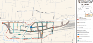
Transportation
Streets and streetscapes facilitate multi-modal movement year-round,
provide valuable frontage for development, and provide the setting for the
range of uses and activities that define Midtown Oakville. A grid of streets
is fundamental to encouraging active transportation and creating a positive
pedestrian experience, which in turn promotes transit use.
a) Significant active transportation, transit, and road infrastructure, as
shown on Schedules C, D, and L3, is necessary to support growth.
Certain existing roads or road segments shall be abandoned,
realigned, widened, extended, or replaced in accordance with this
Plan.
b) The Town may secure rights-of-way on alignments as shown on
Schedules C, D, and L3 through the planning approval process or
through a public land expropriation process. Final rights-of-way shall
be consistent with Schedules C, D, and L3, or otherwise be
determined through detailed transportation studies, environmental
assessments where required, and the planning approval process.
c) The provision of future roads and other transportation infrastructure
shall be coordinated as development progresses to ensure that
transportation infrastructure is provided for new residents and
employees in a timely manner.
d) Subject to section 8.2.3, changes to the requirements, location or
alignment of new transit services, roads, and active transportation
facilities, as shown on Schedules C, D, L3 and L4, will not require an
amendment to this Plan provided that the general intent and purpose
of this Plan is maintained.
e) The rights-of-way of future roads shall be required to achieve the
widths identified on Schedule L3 unless otherwise determined by the
Town through future study and/or confirmed through detailed design.
f) The design and operation of existing and new streets in Midtown
Oakville shall prioritize year-round active transportation and transit
use.
g) The town may require the early conveyance of rights-of-way, prior to
development, to complete the street network.
h) Development shall not preclude the following as contemplated in this
Plan:
i) the realignment and extension of Cross Avenue as a multi-purpose
street;
ii) a new multi-purpose arterial road – the North-South Crossing –
across the QEW/Highway 403 to link to the extensions of Davis
Road and Cross Avenue;
iii) the future local road network as identified on Schedule L3;
iv) a grade separation of the railway at Chartwell Road or an alternate
location east of Trafalgar Road as determined through an
environmental assessment; and,
v) grade-separated active transportation facilities to be located
across:
the QEW/Highway 403, east and west of Trafalgar Road; and,
the railway, east of Trafalgar Road.
f) The Town will work with Halton Region and Metrolinx to:
i) implement the extension of the rail platform east of Trafalgar Road
and improve transit passenger access from the east side of
Trafalgar Road; and
ii) implement relocation of the shared bus terminal to east of
Trafalgar Road.
-
Block Design
To facilitate appropriate block design and coordinated development within
Midtown Oakville, the following policies shall apply:
a) Development blocks are formed by the planned transportation network
and shall be designed comprehensively.
b) Where properties within a block cannot be consolidated so that
development may be coordinated, development on a portion of a block
shall not preclude the development of the remainder of the block in
accordance with this Plan.
c) Blocks should be designed using the perimeter block concept whereby
buildings are situated along the street edges to support a vibrant public
realm, and service spaces and private outdoor amenity areas are
located interior to the block, accessed through strategic breaks in the
street walls of the blocks to facilitate access to service and amenity
space.
d) Development shall promote safe, convenient, and predictable active
transportation circulation routes and mid-block connections, shown
conceptually on Schedule L4, to increase the permeability of blocks
and to maintain physical and visual connections to community
destinations, landmarks, and amenities without boundaries. The
location of mid-block connections should relate to the placement of the
buildings, align with existing or planned active transportation
circulation routes, and be sized in alignment with human-scaled
architecture and design. Potential barriers along these routes, such as
boundary fences or retaining walls, shall be avoided.
e) Mid-block connections shown conceptually on Schedule L4, shall be
provided as publicly accessible active transportation connections,
open space and/or mews that can be accessed by the general public
24 hours a day, year-round. It is the intent that privately-owned publicly
accessible spaces (POPS) provided by development will create the
the mid-block network identified on Schedule L4.
f) Active transportation circulation routes and mid-block connections will
be established through the planning approval process and should
improve and consolidate access to development and enhance
connections and mobility within and through the area.
g) Vehicular access to parking, service facilities and loading areas shall
be planned from local roads. Temporary or interim vehicular access
from an existing road may be permitted as a condition of the planning
approval process, or through an agreement with the Town, until such
time that a new local road and access are constructed.
h) Shared vehicular access, and shared service facilities internal to a
block, with regards to where service facilities are contemplated, are
preferred and shall be pursued through landowner agreements, and
implemented through the planning approval process.
i) Utility vaults, meters, and similar infrastructure shall be located internal
to a development block and/or the buildings, or underground to ensure
a clear and unobstructed public realm.
j) Hydro and other utility transmission lines, where located within a public
right-of-way, should be provided, or relocated, underground, where
feasible, as infrastructure improvements and development progress.
-
Built Form
The tallest buildings in Oakville will be located in Midtown Oakville.
The highest densities are intended north of the railway, with lower
densities south of the railway as a transition to existing residential areas.
Buildings and public spaces will be designed to ensure that the objectives
for creating the community envisioned by this Plan are achieved.
In addition to the policies in Section 6, Urban Design, of this Plan, the
following policies apply specifically to Midtown Oakville. They provide
direction to ensure that the cumulative effective of multiple tall and midrise
buildings in Midtown Oakville contribute to building a strong, livable
community, and incorporate distinctive architecture and built form that
contributes to a unified sense of identity and character for the area.
a) Tall buildings shall be designed to the highest architectural quality and
detail, and shall ensure a pedestrian-oriented built form, provide active
façades oriented to public streets, and contribute to a distinctive
skyline.
b) Buildings shall be designed and sited to maximize solar energy,
ensure adequate sunlight and skyviews, minimize wind conditions on
pedestrian spaces and adjacent properties, and avoid excessive
shadows on the public realm.
c) Multiple towers within a block, development site, or within close
proximity to each other on abutting sites should vary in height from one
another generally by a minimum of 20 metres in order to create
variation in building height and a distinctive skyline for Midtown
Oakville. Exceptions may be permitted for development sites where
two or more towers of the same height is an important design feature.
Building height variation will be reviewed on a site-by-site basis and
implemented through the planning approval process.
d) The distance between the facing walls of towers shall generally be a
minimum of 30 metres.
e) Building setbacks adjacent to public streets are intended to be
landscaped spaces or, where appropriate, extensions of the public
sidewalk that contribute to the character of an area.
f) The height of the building base (podium) for tall buildings should
generally be equivalent to the building-to-building distance across the
adjacent right-of-way, up to a maximum of 25 metres in height, in order
to frame the street and enhance pedestrian comfort.
g) For tall buildings along public streets or publicly accessible amenity
space, a stepback between the podium base and tower portion should
be provided that is generally no less than 5 metres to reinforce the
character of the public realm.
h) For tall buildings, the floorplate of each tower (the portion of the
building above the base or podium) shall generally be no more than
750 square metres to ensure a slender tower profile to minimize
adverse shadowing, maximize sun exposure and enhance the skyline.
i) Green roofs and/or amenity space should be provided on the roof of
any building base or above-grade parking structure where the rooftop
will be visible from nearby tall buildings.
j) Retail and service commercial uses shall be provided on the ground
floor of mixed-use buildings that directly front onto an arterial or
collector road, as reflected on Schedule L3, with the exception of
Chartwell Road. These uses may be extended to other floors.
k) Where provided, ground floor retail and service commercial uses shall
be continuous along a frontage, interrupted only by building lobbies,
transit station entrances, or other public or institutional uses. A
minimum of 70% of the frontage along the ground floor of the building
shall be devoted to retail, service commercial or public uses, unless it
can be demonstrated that there are functional or operational
constraints that warrant relief, as determined through the planning
approval process.
-
Development Density
a) Minimum and maximum density, expressed as floor space indices
(FSI), shall be permitted in accordance with Schedule L2 and the
policies of this Plan, which may permit additional density.
b) Smaller sites are encouraged to consolidate with adjacent lands to
enable a comprehensively designed development that comprises most
of the associated block. As such, notwithstanding subsection (a), sites
less than 2500 square meters in gross area shall be permitted a
maximum density of no more than 0.25 floor space index greater than
the minimum density shown on Schedule L2.
c) The gross floor area calculated by using the maximum floor space
index, as shown on Schedule L2, for a portion of a lot that is to be
dedicated to the Town for a public road, public park, or other public
open space, may be transferred to the retained lot or block and
accommodated on the lot or block as increased density above the
maximum density, as shown on Schedule L2, subject to all other
policies of this Plan. Privately-owned publicly accessible spaces
(POPS) do not qualify.
d) Notwithstanding subsection 20.3.8 (a), on lands designated Urban
Core north of the railway, the following floor areas may be exempt
from the calculation of the floor space index when determining compliance
with the density maximums shown on Schedule L2 and when provided
within a residential mixed-use building, to be implemented through the
planning approval process:
i) the net floor area of
- affordable housing;
- educational facilities;
- community facilities, including daycares;
- urban-format grocery stores with a net floor area greater than
- 2000 square meters;
ii) the net leasable floor area of office space provided above the
ground floor;
iii) up to 50 percent of the net floor area of:
2-bedroom or 3-bedroom units, when provided in
developments where more than 25 per cent of the total
residential units are provided as 2-bedroom or 3-bedroom
units; and
hotels.
e) Required minimum densities are provided on Schedule L2.
Notwithstanding the minimum densities shown on Schedule L2,
minimum densities shall not apply to:
i) lands required for public parks and open spaces;
ii) educational facilities;
iii) community uses operated by a public authority; and,
iv) above ground parking structures operated by a public authority.
f) Reductions to the minimum density required by Schedule L2 may be
considered as part of a comprehensive development application to
provide flexibility in building and site design. Such consideration shall
only be given where it can be demonstrated that the policies of
sections 20.2 and 20.3 of the Plan are met and the planned
intensification for the site(s) can still be achieved.
g) Notwithstanding the minimum density shown on Schedule L2, building
additions, alterations and/or replacements to existing development
may be permitted, where they can be demonstrated not to preclude
the long-term redevelopment of the property as set out in this Plan.
By-law 2023-###, Appendix “A” (OPA XX to the Livable Oakville Plan) Page A-20
-
Housing
a) Within Midtown Oakville, residential development should include:
i) a range of housing options in terms of building types, unit types
and sizes, and tenure to accommodate a variety of households,
including those with children;
ii) amenities designed specifically for households with children;
iii) affordable housing; and,
iv) purpose-built rental housing.
-
Educational Facilities
Midtown Oakville provides a unique opportunity to accommodate a
growing urban community and providing educational facilities in a high
density, mixed-use, urban community. The policies establish a framework
by which school boards can identify the need for educational facilities and
engage the development community to acquire educational facility space
within a proposed mixed-use development.
The policies contained within this Plan are intended to support the Midtown
Oakville urban community secure access to educational facilities and
shared use of public park space. These policies are representative of a
shift from a suburban greenfield-focused school model to an integrated
urban school model. This Plan recognizes the importance of planning at
the outset for school boards to have the ability to acquire school space
within a mixed-use development, as it is required.
a) A public school board may determine that real property, or a lease, is
required for an educational facility as development proceeds and
projected demand aligns with student population. As such:
i) Any landowner proposing to develop or redevelop a mixed-use
building within the Urban Core designation in Midtown Oakville
shall be required to notify all of the public school boards of
proposed development plans as part of a complete planning
application, to provide the school boards with an opportunity to
determine a need for an educational facility space within the
proposed development; and,
ii) The Town may require, as part of a complete application, written
confirmation from the school boards that the developer has
provided them the opportunity to determine a need for education
facility space within the proposed development.
b) Educational facilities should be planned and designed to meet the
requirements of public school boards for an urban, higher-density
community, and should:
i) be incorporated into mixed-use developments and are encouraged
to provide outdoor space through a combination of space on
building podiums, at-grade and/or through shared use of nearby
public park space through an appropriate shared use agreement
with the Town;
ii) have floor area distributed vertically to minimize floor plates and
make efficient use of land;
iii) have prominent pedestrian entrances on the main building façade
fronting onto a public street which are clearly visible and directly
accessible from a sidewalk on a public street;
iv) be co-located in mixed-used buildings, where possible, and
provide for integrated pick-up and drop-off areas, as applicable;
v) be located adjacent to parks and open spaces, specifically Public
Commons, where possible, to enable synergies between facilities
and potential shared use of public park space, where appropriate
and applicable;
vi) be designed to enable local community use outside of school
hours; and,
vii) when entering into a shared use agreement with the Town to use
public park space, limit obstructions or physical buffers that inhibit
access to and movement through public parks, such as fences
within or enclosing public parks, to allow for a holistic and flexible
park design which enables community activity in the park during
and outside of school hours.
- Public Service Facilities
a) The Town shall monitor public service facility needs as Midtown
Oakville develops, and works with Halton Region and public agencies to
enable the development of required facilities as they are identified.
b) New public service facilities shall be provided in a timely manner to
support growth.
c) Public service facilities should be planned and designed to meet the
requirements of the Town and/or public agencies, and should:
i) be provided in visible locations with strong pedestrian, other active
transportation and transit connections;
ii) be co-located in mixed-used buildings, where possible, and
provide for integrated pick-up and drop-off areas, as applicable;
iii) be located adjacent to parks and open spaces to enable synergies
between facilities, where appropriate and applicable; and,
iv) provide for multi-functionality through flexible, accessible, multipurpose spaces that can be programmed in different ways and can
adapt over time to meet the evolving needs of the community.
d) Development may be required to contribute to the delivery of
community service facility, through contributions to a community
benefits charge, needs identified through the planning approval
process or other Town master plan or strategy by providing:
i) new space for on-site community facilities;
ii) new space for off-site community facilities within an appropriate
distance; and/or,
iii) a contribution towards a specific community service facility that
meets identified needs.
e) Landowners, public agencies, and/or non-profit community service
providers are encouraged enter into partnerships to support the
provision, improvement and expansion of public service facilities.